Interested in a unique walking or cycling tour? Consider our experiential map as a guide. The first edition features 15 places of interest, including:
- 11,000-year-old hunting camps at Vermilion Lakes;
- ornate Indigenous reliefs located on the river-facing sides of the Bow River Bridge,
- four museums, each offering a different experience of Indigenous culture; plus,
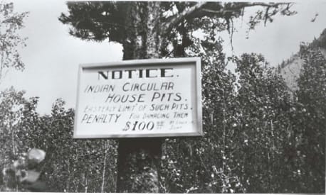
- the location of a Shuswap-style pit-house village under the Banff Springs Golf Course.
Each site is complemented with an insightful description, either here, or on the back of the printed map.
Highlighting Banff’s Indigenous past often overshadowed by settler stories, the map gives us all – Indigenous, settler, new immigrant or visitor to Canada – the opportunity to experience a UNESCO World Heritage Site with new eyes. It is an exciting journey of discovery.
ELDER-INSPIRED
The idea for Banff’s Indigenous Experiences Map developed through multiple conversations at the annual Gathering of Elders held at the Juniper Hotel.
Tim Patterson of the Lower-Nicola First Nation, and Steve Ellis, an Inuit who grew up in Banff, assembled an initial list of sites. They considered:
- material and spiritual relationships with the land;
- the Bow Valley as part of the ancestral homeland of the Stoney Nakoda Nation;
- Banff’s history as a gathering place for the Kanai, Siksika, Piikani, Tsuu T’ina, Ktunaxa, Cree, Secwepemc, and Métis; and,
- colonial encounters that led to dispossession.
Bowstrings worked with Tim and Steve and several Stoney Nakodas to pick 26 visit-worthy sites for the map. We complemented this work with archival research and a literature review. From there, we presented the choices and descriptions to the 2023 Gathering of Elders for further input. It was tough to narrow down the options to an initial 15. The Bow Valley has such a rich, varied and important history for so many First Nations.
Bowstrings will continue to consult with Elders and story-holders in perpetuity. We envision the Indigenous Map as a living document. Never truly finished, it is a place where stories, sites, and locations will be added, and new editions published, as more voices are heard.
HISTORICAL CONTEXT
Before Europeans, Banff was a site of cultural exchange with deep spiritual meaning for First Nations on both sides of the Rockies. As a result, many sites within and around the Banff townsite remain important to First Peoples.
Remarking on this general lack of awareness, in 2002, Perry and Langemann declared “a need for Aboriginal communities to have a voice in telling their own story in interpretive material presented in the Park”. 1
Trouillot’s thoughtful exploration of power and the production of history2 is helpful here. His theory provides insight into how Banff’s Indigenous history has been silenced in favour of settler perspectives.
Banff National Park’s 2018 ‘State of the Park Assessment‘ is telling. In the category of Indigenous Relations, the rating is “Not Rated”. This decision clearly supports the ongoing need to add Aboriginal voices to our understanding and experience of the Park.
Created through conversations with Indigenous Elders and traditional knowledge keepers, supported by academic research, this living map is one way to speak into the silence.
Footnotes and Photo Credits
1 Langemann, E.G. and W. Perry. 2002. Banff National Park of Canada: Archaeological Resource Description and Analysis. Unpublished report, page 145. Parks Canada: Calgary, AB.
2 Trouillot, M.R. 1995. Silencing the Past: Power and the Production of History. Beacon Press, Boston, MA.
3 Notice Photo: Sourced from the 1914 Handbook of the Rocky Mountain Parks Museum. Department of the Interior, Dominion Parks Branch, Government Printing Bureau, Ottawa, ON.
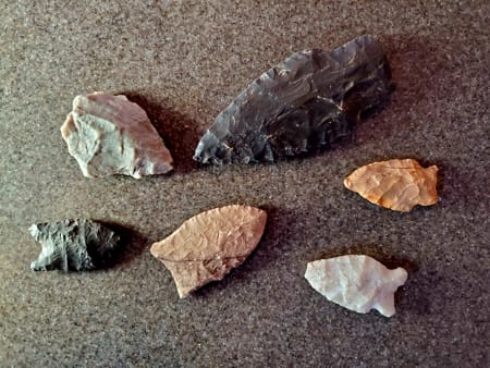
4 Flint-knapped arrowheads found by George MacArthur in the same Alberta location as several ancient buffalo skulls. Photo: Beth Gallup